The Inca Trail, a 26-mile (42 km) trek through the Andes Mountains of Peru, is one of the world’s most famous and rewarding hikes. This ancient path leads travelers through stunning mountain scenery, cloud forests, and subtropical jungle to the lost city of the Incas – Machu Picchu. More than just a trek, the Inca Trail is a journey through time, offering hikers a glimpse into the remarkable civilization of the Inca Empire.
- Historical Significance
- The Route
- Day 1: Kilometre 82 to Wayllabamba
- Day 2: Wayllabamba to Pacaymayo
- Day 3: Pacaymayo to Wiñay Wayna
- Day 4: Wiñay Wayna to Machu Picchu
- Key Sites Along the Trail
- Flora and Fauna
- Practical Information
- Best Time to Hike
- Permits and Regulations
- Physical Preparation
- What to Pack
- Altitude Sickness
- Alternative Routes
- Cultural Considerations
- Conclusion
Historical Significance
The Inca Trail was part of a vast network of roads built by the Incas to connect their vast empire, known as Tawantinsuyu. This particular route served as a pilgrimage path to Machu Picchu, a royal estate and sacred site. Today, it stands as a testament to Incan engineering prowess, with much of the original stonework still intact.
The Route
The classic Inca Trail is typically completed in 4 days and 3 nights, though shorter and longer variations exist. Here’s a breakdown of the typical itinerary:
Day 1: Kilometre 82 to Wayllabamba
- Distance: 7.5 miles (12 km)
- Elevation Gain: 1,200 feet (366 m)
The trek begins at Kilometre 82, crossing the Urubamba River. Hikers pass through small villages and see their first Incan ruins at Llactapata.
Day 2: Wayllabamba to Pacaymayo
- Distance: 6.8 miles (11 km)
- Elevation Gain: 4,000 feet (1,220 m)
This is the most challenging day, climbing to Dead Woman’s Pass at 13,828 feet (4,215 m). The views of snow-capped peaks are breathtaking.
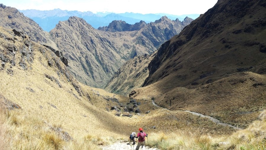
Day 3: Pacaymayo to Wiñay Wayna
- Distance: 9.3 miles (15 km)
- Elevation Change: Varied
Hikers pass through diverse ecosystems and several impressive Incan sites, including Runkurakay, Sayacmarca, and Phuyupatamarca.
Day 4: Wiñay Wayna to Machu Picchu
- Distance: 3.1 miles (5 km)
- Elevation Change: Mostly descent
An early start leads to the Sun Gate (Inti Punku), offering the first views of Machu Picchu. The trail then descends into the ancient city itself.
Key Sites Along the Trail
- Llactapata: An Incan ruin that may have served as a rest stop and supply station.
- Dead Woman’s Pass: The highest point of the trek, offering panoramic views of the surrounding mountains.
- Runkurakay: A small, circular ruin that may have been a watchtower or rest stop.
- Sayacmarca: An intricate site perched on a rocky spur, its name means “Inaccessible Town.”
- Phuyupatamarca: Known as the “Town Above the Clouds,” it features ritual baths and impressive views.
- Wiñay Wayna: One of the most beautiful sites on the trail, with agricultural terraces and ceremonial structures.
- Inti Punku (Sun Gate): The final passage to Machu Picchu, offering the classic postcard view of the lost city.
Flora and Fauna
The trail passes through diverse ecosystems, from high alpine tundra to lush cloud forests. Hikers may spot:
- Andean spectacled bears
- Cock-of-the-rock (Peru’s national bird)
- Various hummingbird species
- Orchids and bromeliads
Practical Information
Best Time to Hike
The dry season (May to September) is ideal. The trail is closed in February for maintenance.
Permits and Regulations
- Only 500 permits are issued per day (about 200 for tourists, the rest for guides and porters).
- Permits must be booked months in advance, especially for the peak season.
- Hiking independently is not allowed; you must go with a licensed guide.
Physical Preparation
The trail is challenging due to the altitude and steep ascents/descents. It’s advisable to:
- Arrive in Cusco a few days early to acclimatize
- Engage in cardiovascular exercise before the trip
- Consider a shorter trek if you’re concerned about fitness levels
What to Pack
- Sturdy hiking boots
- Layers of clothing (temperatures can vary greatly)
- Rain gear
- Sunscreen and insect repellent
- Reusable water bottle
- Snacks
- Camera
Altitude Sickness
Be aware of symptoms like headache, nausea, and shortness of breath. Stay hydrated and consider medication like Diamox (consult your doctor).
Alternative Routes
For those unable to secure permits or looking for different experiences:
- Short Inca Trail: A 2-day option starting closer to Machu Picchu.
- Salkantay Trek: A more challenging 5-day trek with diverse scenery.
- Lares Trek: Less crowded, offering more interaction with local communities.
Cultural Considerations
- Respect sacred sites and local customs.
- Learn a few basic Quechua phrases to connect with local porters.
- Consider the environmental impact of your trek and practice Leave No Trace principles.
Conclusion
The Inca Trail is more than just a hike; it’s a journey through history, offering a unique blend of natural beauty, archaeological wonders, and physical challenge. As you walk in the footsteps of the Incas, ascending through cloud forests and ancient stone staircases, you’ll gain a profound appreciation for the ingenuity of this ancient civilization. The culmination at Machu Picchu, emerging from the mist as it has for centuries, is a moment that will stay with you long after you’ve returned home. Whether you’re a history enthusiast, nature lover, or adventure seeker, the Inca Trail offers an unparalleled experience in one of the world’s most mystical landscapes.